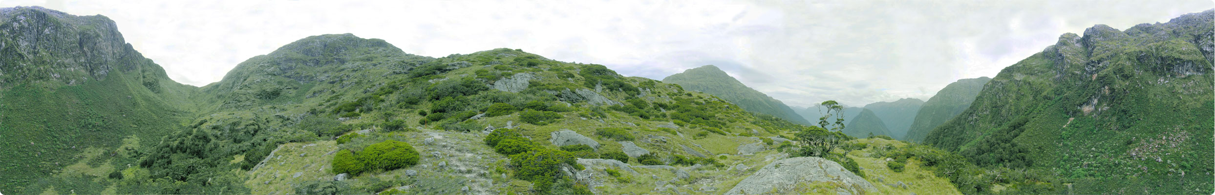
I'll do the best that I can
to walk you
through the picture starting at
the left. You see a hint of the rock walls to the very
left. I could hear the keas calls echo off them as the track
climbed. Next, the green area that dips down is Centre
Pass. The trail
goes up the right-hand side and then crosses a stream in the middle and
you finish the climb on the on the left hand side. It's
pretty
steep those last hundred meters. This section of the
picture is a little fuzzy, due to different exposures between the
individual photos (sorry, I'm not a photo expert). Moving
along
the right, the mountain you see to the right of Centre Pass leads to
the top of Mt. Memphis, which is not visible
in this photo as it's way up high and far behind, but start climbing
to the right of the pass and eventually you'll get to the top, You'll
see that in another
picture and boy is that a great one.
If you keep on going to the
right and look near the bright green bushes in the foreground, you'll
see an orange snow pole and a nearby rock cairn (pile of rocks that
mark the trail). Follow the snow poles and rock cairns and
you'll
be fine crossing the pass. Continuing onto the right, look to
the
left of the tree and you'll see another rock cairn and the trail
itself. It's a bit hard to see these on the low-resolution
photo. They are visible on the larger panoramas. To
the
right of the tree is Tripod Hill and what an
impressive mountain that is...from any
angle. Notice how scrubby and stunted the trees are up
here? The
weather must be pretty harsh from the look of them. To the
right
of
Tripod Hill, you will see two
mountains. Between these two mountains lies a deep valley and
at
the beginning of the valley, way down low, is the Kintail Hut and where
the climb for the day began. Continuing on to the right you
see
more of the steep rock faces and that eventually goes 360 degrees
around and returns to where we started!