Northwest Circuit:
The Northwest Circuit is a 125-km trail that follows the
northern
coast of Stewart Island. It's know for it's beaches, kiwi
sightings, and mud. It's even possible to be knee deep in the
slop & see a kiwi at the same time. Well, it's a
great track,
read on for more.
Bungaree Hut:
 The Northwest Circuit begins on a pleasant bay that looks across the
endless ocean. The first section of the track is easy as
it’s
part of the Rakiura Track and soon comes upon Maori Beach, where a
stream glittered with gold flecks, which in the brilliant sun looks
like liquid metal. From there, it goes back into a forest so
thick with tree ferns that it was as dark as the evening. It
was
a casual walk with the track gently going up and down before descending
to Magnetic Beach, which was covered in interesting patterns in the
sand formed by water flowing down to the ocean. The sun was
warm
but the breezes just enough to stay cool. A few hours later,
I
reached the Port William Hut where a DOC worker warned me about a group
of hunters at the next hut who had generated some complaints.
Hmmm...does not sound good.
The Northwest Circuit begins on a pleasant bay that looks across the
endless ocean. The first section of the track is easy as
it’s
part of the Rakiura Track and soon comes upon Maori Beach, where a
stream glittered with gold flecks, which in the brilliant sun looks
like liquid metal. From there, it goes back into a forest so
thick with tree ferns that it was as dark as the evening. It
was
a casual walk with the track gently going up and down before descending
to Magnetic Beach, which was covered in interesting patterns in the
sand formed by water flowing down to the ocean. The sun was
warm
but the breezes just enough to stay cool. A few hours later,
I
reached the Port William Hut where a DOC worker warned me about a group
of hunters at the next hut who had generated some complaints.
Hmmm...does not sound good.
 After
the hut, the Northwest Circuit diverges from the more popular
Rakiura Track and there would be less maintenance and more mud, so it
was time to put on the gaiters. It didn’t take long
for the
gaiters to prove very handy. There was a section where the
boardwalk stopped and the track ascended a steep, muddy, and slippery
section. It was exhausting pushing through brush, enduring
thorns, and hanging onto tree branches. I looked for the
track,
but couldn’t follow it. After 5-10 minutes, I
descended back to
the boardwalk to see if something had been missed. I looked
fifty
meters to the right and saw more boardwalk. The trail was
right
next to me, but completely overgrown, and I had followed the footsteps
of others who made the same mistake. D’oh!
After
the hut, the Northwest Circuit diverges from the more popular
Rakiura Track and there would be less maintenance and more mud, so it
was time to put on the gaiters. It didn’t take long
for the
gaiters to prove very handy. There was a section where the
boardwalk stopped and the track ascended a steep, muddy, and slippery
section. It was exhausting pushing through brush, enduring
thorns, and hanging onto tree branches. I looked for the
track,
but couldn’t follow it. After 5-10 minutes, I
descended back to
the boardwalk to see if something had been missed. I looked
fifty
meters to the right and saw more boardwalk. The trail was
right
next to me, but completely overgrown, and I had followed the footsteps
of others who made the same mistake. D’oh!
The boardwalks ended and would not be seen for another 110 km. but the
track continued through the forest where I met a guy coming the other
way who warned me about the hunters hassling him. Hmmm...does
not
sound good. The skies clouded up and the rains
fell. By the
time I reached Bungaree Beach, the rain was pouring down and the winds
were howling. I was getting sandblasted on the
beach; so
crossing with my head down was the only option to reach the
hut.
Half an hour later, two forlorn figures crossed the beach, they too
getting sandblasted, heads down. This couple was Tom and
Anne,
from England and Germany, with whom I would walk the track until nearly
the end.

 Later the hunters arrived back at the hut. They were friendly
and
shared their venison stew. They got a big kick out of me
running
around in striped long underwear and called me "Moose." They
weren’t bad guys and didn’t get too drunk, but it
is unlikely to have
six hunters and a quiet hut, though some might take their bantering as
hassling.
Later the hunters arrived back at the hut. They were friendly
and
shared their venison stew. They got a big kick out of me
running
around in striped long underwear and called me "Moose." They
weren’t bad guys and didn’t get too drunk, but it
is unlikely to have
six hunters and a quiet hut, though some might take their bantering as
hassling.
Stewart Island is known for its mud, but it really wasn’t
that
bad. Certainly not as bad as on the Dusky Track, but it was a
long track and given that it rains about five meters (200 inches) a
year on Stewart Island, there was plenty of time for things to
change.
It
was a good day as a whole. Most of the time, the weather was
exceedingly pleasant and the skies and oceans wonderful shades of
blue. The last little stretch of harsh weather, oh that
wasn’t so
bad.
Christmas Village Hut
Upon leaving the hut, the track started to climb. The track
would
go up a ridge, then down the ridge, come to a stream with a short,
steep, muddy descent to the water’s edge followed by a short
ascent
away from the steam and then a long climb up a ridge. This
pattern would continue the entire day; actually this would be the
pattern for most of the track. I came upon Tom and Anne and
we
were joined by a couple of fantails. Trying to photograph a
fantail can be difficult as they constantly flit around. They
land on a branch, turn around once or twice, and fly to another branch,
resulting in many photographs of empty branches. I kept
trying to
get their picture, but the fantails followed Tom and Anne through the
forest instead of sitting with me.

 Up and down, up and down, it continued. The mud
wasn’t that bad,
it was frequent but not deep. The track descended to Murray
Beach, which was sunny and windy. There was a steep climb on
the
north side of the beach where trees became fewer and the undergrowth
thicker. Still, the track continued the pattern of up a
ridge,
down a ridge, across a stream, then back up a ridge.
Occasionally
the trail became tedious, but not too much.
Up and down, up and down, it continued. The mud
wasn’t that bad,
it was frequent but not deep. The track descended to Murray
Beach, which was sunny and windy. There was a steep climb on
the
north side of the beach where trees became fewer and the undergrowth
thicker. Still, the track continued the pattern of up a
ridge,
down a ridge, across a stream, then back up a ridge.
Occasionally
the trail became tedious, but not too much.
At the end of the day, I started to tire a little but was buoyed when I
heard the ocean surf and knew the hut was nearby. It was a
pleasant day with a lot of good times and the weather so very
nice. I had a few doubts whether I wanted to
continue. I
wasn’t sure I wanted to hike 8-12 days of this type of
track. It
wasn’t bad or difficult, but it wasn’t as
spectacular as
Fiordlands. My friend Gareth said the track could be a slog
through the mud and bush that seemed to go on and on. I was
starting to feel that way. However, there were pleasant times
sitting by a stream, listening to the water, and feeling the warmth of
the sun.
Yankee River Hut
 Yesterday I sauntered and today was the same, frequently stopping to
enjoy the pleasant weather. It was a muddy, muddy
day.
Again, the mud isn’t thigh-deep like the Dusky Track, rather
boot-deep
to maybe calf-deep, but it keeps up all day. There are
sections
of the trail with half a kilometer of nothing but mud. Up a
ridge, down a ridge it continued. At the halfway point for
the
day was Lucky Beach. It’s a nice break from the
forest, sitting
and watching the ocean, but then it was back to the bush.
Yesterday I sauntered and today was the same, frequently stopping to
enjoy the pleasant weather. It was a muddy, muddy
day.
Again, the mud isn’t thigh-deep like the Dusky Track, rather
boot-deep
to maybe calf-deep, but it keeps up all day. There are
sections
of the trail with half a kilometer of nothing but mud. Up a
ridge, down a ridge it continued. At the halfway point for
the
day was Lucky Beach. It’s a nice break from the
forest, sitting
and watching the ocean, but then it was back to the bush.
I began to tire of the mud and had doubts about finishing.
The
forest was luxurious but one hour was hard to distinguish from the
next. The track continued and it was mud, mud, and more
mud. Late in the day, my energy started to flag. I
ate a
little and forced myself into a set pace. It’s
important to eat
adequately when tramping and it’s been a little light on the
food the
last days. I heard the ocean surf and saw a very tall
ridge. The thought of climbing that ridge was an unhappy one,
but
then the track turned and followed the river downstream to the
sea. I knew the hut was close when seeing placid swells
rolling
upstream from the surf.
 It was a decent day of walking but there were doubts about continuing
due to boredom. Tom had previously tramped the track and
said, “I
was a little bored with the first few days, but best part starts
tomorrow.” I didn’t realize how right he
would be. The hut
was right along the ocean and we each had a room of our
own. I went outside to wash my clothes but was
absolutely
mobbed by sandflies, dirty clothes it will be. The day
wasn’t
that bad and my spirits revived, so if the worst part was sandflies, it
was ok.
It was a decent day of walking but there were doubts about continuing
due to boredom. Tom had previously tramped the track and
said, “I
was a little bored with the first few days, but best part starts
tomorrow.” I didn’t realize how right he
would be. The hut
was right along the ocean and we each had a room of our
own. I went outside to wash my clothes but was
absolutely
mobbed by sandflies, dirty clothes it will be. The day
wasn’t
that bad and my spirits revived, so if the worst part was sandflies, it
was ok.
Long Harry Hut
Just as we were getting ready to leave in the morning, six fishermen
arrived with an unbelievable amount of gear. They were nice
guys
and undoubtedly would have shared whatever they caught, but I was glad
I was moving on for the night. Right out of the hut, the
track
climbed steeply for a few hundred meters, muddy all the way
up. I
was fresh for the day and had eaten properly, so the ascent was
easy. At the top, I could hear the ocean waves breaking on
next
beach ahead. Then the track started the typical up and down,
but
eventually turning gentle and dry and finally into the scrubby trees
found along the ocean. From there I got my first view of the
extensive sand dunes along Smokey Beach. The track descended
into
the dunes, where I met Tom and Anne. The dunes are
so
atypical of the track, normally there is something growing absolutely
everywhere, but the dunes were barren.

 We crossed the sand dunes and beach and forded a stream and started a
steep (and muddy) climb. From the top, a gentle trail
surrounded
by moss began, gradually undulating up and down, but slowly descending
to the Long Harry Hut. The forest was lush and green and as
nice
as anyplace on the entire trail. It’s such a magic
feeling to be
in such a forest.
We crossed the sand dunes and beach and forded a stream and started a
steep (and muddy) climb. From the top, a gentle trail
surrounded
by moss began, gradually undulating up and down, but slowly descending
to the Long Harry Hut. The forest was lush and green and as
nice
as anyplace on the entire trail. It’s such a magic
feeling to be
in such a forest.
At the hut was a tiny tent not even big enough for a child.
It
was for a penguin-tracking dog that belonged to a researcher.
This woman had also done some work trapping cats on the
island. I
asked her what she did when she found a cat. “Kill
it.”
“How?” “With a
hammer.” She didn’t like that part of her
job but said, “What’s the alternative?
Let the cats kill all the
native wildlife?” She’s correct, but that
hammer thing sounds
pretty graphic.
Today was a turning point. I started to appreciate the track
and
for the first time in two days had no doubts about being
there.
It wasn’t that the last few days were bad, just monotonous
and the
trail would only get better.
East Ruggedy Hut
It was raining in the morning and we waited until noon to
leave.
It’s often pointless to wait as you can be waiting for days,
so if it
hadn’t stopped, we would have still gone tramping in the
showers.
The day started with a steep and (and you know word that comes
next…It
begins with an ‘M’) climb and began the M-word ups
and downs.
This continued until there was a steep, slick downhill. I
finally
caught up with A&T on this hill. Why?
Because the
descent was “EYAH...YA..EEE….Oh, avoid that
tree….EEEKKK…watch out for
that rock”, sliding all the way down.
 I got out ahead of them and walked through calf deep mud when something
crossed the track ahead. It was too upright to be a
possum
but hard to tell what it was. “Could it be
a....?” I heard
it running through the forest and circled around, emerging from the
trees, no more than 1.5 meters away. Yep...a kiwi!
It
looked at me and went back into the woods. It was an
attractive
bird, light brown with whitish spots and yes, a long beak.
I got out ahead of them and walked through calf deep mud when something
crossed the track ahead. It was too upright to be a
possum
but hard to tell what it was. “Could it be
a....?” I heard
it running through the forest and circled around, emerging from the
trees, no more than 1.5 meters away. Yep...a kiwi!
It
looked at me and went back into the woods. It was an
attractive
bird, light brown with whitish spots and yes, a long beak.
A&T were not far behind and I motioned to them to be
quiet.
Tom walked on while Anne & I waited for the kiwi. A
few
minutes later the kiwi appeared on the left side of the trail but
disappeared. Then it appeared again, but on the right side of
the
trail. We didn’t know how it crossed the trail, but
a minute
later, the kiwi walked a meter away from us, probing the ground for
food. It went: poke, poke, poke, poke and slowly
went back
into the woods, sheltering under a tree. We waited ten
minutes,
but it was still hiding. At a certain point, one has to leave
it
alone to go about its business. This forest belongs to it,
not
us, and we were preventing it from feeding, so we took off. On the way
past the tree, I quickly looked underneath and saw two beaks.
No
wonder “it” was able to cross the trail without us
noticing because
“it” was a “they”!
 From there, we continued to push through the brush and the mud turned
knee-deep. There was a steep descent to a rocky beach where
we
met back up with Tom and sat in the mid-day sun. Then guess
what!? An M-word climb, after which we got our first view of
the
Ruggedy Islands, which are rocky islands jutting out of the sea that
are quite rugged—just like their name. The winds
had been picking
up over the last hour and the weather started to look
questionable. If you stayed low, it was ok, but climb above
the
vegetation to look at the Ruggedys and one was pummeled by strong
winds. From there, it was a steep descent down to a sandy
plain
and the rains began.
From there, we continued to push through the brush and the mud turned
knee-deep. There was a steep descent to a rocky beach where
we
met back up with Tom and sat in the mid-day sun. Then guess
what!? An M-word climb, after which we got our first view of
the
Ruggedy Islands, which are rocky islands jutting out of the sea that
are quite rugged—just like their name. The winds
had been picking
up over the last hour and the weather started to look
questionable. If you stayed low, it was ok, but climb above
the
vegetation to look at the Ruggedys and one was pummeled by strong
winds. From there, it was a steep descent down to a sandy
plain
and the rains began.
We walked inland, getting sandblasted in the raging winds and had to
cross a river. There was no obvious crossing point and
everywhere
was too deep to see bottom. I chose a spot and forged across
the
river. It was a strange sensation to feel my feet sink deeply
into the sand, but a stranger feeling was tripping on an underwater
tree and going face first into the water. I stood back up in
the
middle of the river in the howling winds and rain and raised my hands
to the heavens yelling ‘AAAAAAAHHHHHHHH!!!!!” as if
to say, “Yes, I
fell, but I’m back up!” It sure felt good
and seemed like the
thing to do. It was a tiring twenty-minute walk to the hut
through the soft
sand. Step...sink, step...sink, step...sink. It was
nice to
get into dry clothes after that up-close-and-personal encounter with
the river.
A short time later, we were joined by three Americans, Mike, Rob, and
Sarah. At first I didn’t like them, nothing they
did wrong,
rather I had gotten used to being with Tom and Anne and anyone else
seemed an intrusion. Sometimes in the bush, it takes time to
get
used to people. The day had a few hard parts with weather and
trail, but we had seen a kiwi and nothing could take that away.
Hellfire Hut

 It was an easy forest walk out of the hut and then a climb down rocks
that looked more at home in a desert than southern New Zealand. The
last two days, the trail had really diversified and was becoming more
and more interesting. The track descended to the dunes of
West
Ruggedy Beach and the first glimpse of Codfish Island.
It’s one
of the last homes of the kakapo, a big, fat, friendly, musky smelling,
green, nocturnal, and flightless parrot. Yep, it’s
all of those
things. Only eighty-six kakapo remain in the world due to
harmful
introduced species. They’ve been taken off of
mainland NZ and
placed on three offshore islands that have been rendered
pest-free. This way they can, hopefully, recover their
numbers
without threat of man or other pests. I looked at the island
and
thought, “It has to happen there or they all go
away.” It’s kind
of sad that it’s come to that point, but seeing the island
gave me hope
that maybe humans are realizing some of their mistakes...well, at least
a few humans are.
It was an easy forest walk out of the hut and then a climb down rocks
that looked more at home in a desert than southern New Zealand. The
last two days, the trail had really diversified and was becoming more
and more interesting. The track descended to the dunes of
West
Ruggedy Beach and the first glimpse of Codfish Island.
It’s one
of the last homes of the kakapo, a big, fat, friendly, musky smelling,
green, nocturnal, and flightless parrot. Yep, it’s
all of those
things. Only eighty-six kakapo remain in the world due to
harmful
introduced species. They’ve been taken off of
mainland NZ and
placed on three offshore islands that have been rendered
pest-free. This way they can, hopefully, recover their
numbers
without threat of man or other pests. I looked at the island
and
thought, “It has to happen there or they all go
away.” It’s kind
of sad that it’s come to that point, but seeing the island
gave me hope
that maybe humans are realizing some of their mistakes...well, at least
a few humans are.
I crossed the beach and the winds were blowing and the waves were
correspondingly large. The beaches that face the prevailing
western winds have quite a bit of debris, from driftwood to fishing
nets, floats, and crayfish traps. Trail markers are often
made
from this refuse and I followed the fishing markers up the requisite
steep climb after a beach. Some parts of the track were ok
while
other parts were wonderfully mossy. Most of the streams had
foam
in them. Tannic acid from the trees makes the water dark and
foamy. It’s not harmful to drink, though not
appetizing.
One stream was the color of root beer and completely covered in
foam. I didn’t know how deep it was and kept
reaching for the
bottom with my foot while holding onto the riverbank. Next
thing
I knew I was waist deep in the water, surrounded by foam.
Can’t
say I liked that, but if you want to stay clean and dry, it’s
best to
stay off the Northwest Circuit.

 The climb continued up and up and eventually crested and then back into
the scrubby trees of the exposed ridges. Had some fun bush
bashing (going off trail) walking to some rocky spires, from where I
could see Codfish Island and beyond that the swells of the sea that
went to the horizon. The trail descended into mossy forests
and
came upon Waituna Beach. I could see the Ruggedy Islands and
high
above on the ridgelines were the spires that I encountered earlier in
the day.
The climb continued up and up and eventually crested and then back into
the scrubby trees of the exposed ridges. Had some fun bush
bashing (going off trail) walking to some rocky spires, from where I
could see Codfish Island and beyond that the swells of the sea that
went to the horizon. The trail descended into mossy forests
and
came upon Waituna Beach. I could see the Ruggedy Islands and
high
above on the ridgelines were the spires that I encountered earlier in
the day.
After that it was, naturally, more muddy climbing up the
ridge.
Upon reaching the top, the mud became the worst of the track. My
journal read, “It was demoralizing. Deep, long, and
sticky.” Or was it “stinky,” I
can’t read my writing there and
could well have been both. The trail descended into a sandy
area;
from there it was back into the forest and then the hut appeared.
The Hellfire Hut was on a tall, sandy ridge that descended to
the ocean
and overlooked the Ruggedy Flats. This is a large, low-lying
area
in the center of the island surrounded by the tall ridges. In
a
few days, the track would be crossing the flats and one could only
surmise that it will be quite sodden. The weather was windy,
but
pleasant. The beaches were nice and the waves were breaking
large. Yes, the mud was a pain in the backside, but the trail
was
diverse and view from the hut was quite simply, out of this world.
Mason Bay Hut

 As is so common, it was raining in the morning and I waited until it
cleared up at 11:30. Anne and Tom decided to spend another
night
at the Hellfire Pass Hut, so I said goodbye to them. Most of
the
time, I’d rather be in the huts by myself, but if someone had
to be
there, they were a pretty good pair. They’re both
pleasant and
kind with a gentle sense of humor. Once the rain stopped, it
would become a fantastic day for tramping. The skies were
blue
and it was warm, but not too warm. From the hut, it was a
couple
hundred-meter climb, naturally with some mud, and then the track
followed along the ridge top for seven km. In one view, there
was
Codfish Island, Hellfire Beach, and off in the distance was Mason
Beach, which was the destination for the day. The winds were
blowing, but the scrubby brush protected me. When standing on
a
rock above the brush, the full force of the wind would nearly knock me
over.
As is so common, it was raining in the morning and I waited until it
cleared up at 11:30. Anne and Tom decided to spend another
night
at the Hellfire Pass Hut, so I said goodbye to them. Most of
the
time, I’d rather be in the huts by myself, but if someone had
to be
there, they were a pretty good pair. They’re both
pleasant and
kind with a gentle sense of humor. Once the rain stopped, it
would become a fantastic day for tramping. The skies were
blue
and it was warm, but not too warm. From the hut, it was a
couple
hundred-meter climb, naturally with some mud, and then the track
followed along the ridge top for seven km. In one view, there
was
Codfish Island, Hellfire Beach, and off in the distance was Mason
Beach, which was the destination for the day. The winds were
blowing, but the scrubby brush protected me. When standing on
a
rock above the brush, the full force of the wind would nearly knock me
over.
Eventually the trail descended, it was extremely muddy, mid-calf to
knee deep. Actually, the mud made descending
easier.
Shallow mud is slippery as you constantly fight your downhill
momentum. In many places, the mud was deep enough to absorb
your
momentum, making it safer, albeit messier.
The trail was absolutely endless mud during the long descent to the
beach. It was downhill in the mud, downhill in the mud; in
the
steepest places, hanging onto branches for safety. The forest
was
mossy, green, and beautiful, but eventually turned into the coastal
scrub and Little Hellfire Beach. There were large waves
breaking
on the shore from the strong winds; I had to lean into to avoid being
blown over. When walking across a pile of driftwood, a gust
of
wind blew me off my feet onto the wood. I wasn’t
hurt but it’s
scary how easily one could break a rib or wrist.
From there it was the standard climb through the different forest
levels. It looked like a very short climb. I
started to
tire on it, mostly because I was expecting a short one, not one that
was 250 meters high. The trail leveled out and soon the
sounds
weren't the last beach but the next one, which would be the last beach
of the track.
It was another Northwest Circuit descent and I could look down far
along the ocean’s shore. It made me sad to think
that this would
be the last of the muddy descents. I know that sounds bizarre
considering how fed up I was earlier on the track, but I was already
missing what lay behind. There were a few raindrops on the
descent and the track turned from green to the brown scrub and gave way
to Mason Beach.

 The beach was covered in driftwood and then a few hundred meters of
rounded rocks strewn across the beach followed by a wide, five-km long
sand beach. The winds died down and I watched the overlapping
waves form rings in the water that covered up my footsteps.
Inland was a bizarre landscape of dunes and hills. All along
the
beach were lots of oystercatchers and gulls. I
don’t like gulls
in a city, flying rats they be, but in their natural element, they are
a pleasure to watch. It was so nice with gentle sun shining
down. I crossed a wide, shallow river with nice ripple
patterns
in the riverbed and then headed a km. upstream to the Mason Bay
Hut. I met the three Americans again and spent some
time
with them. Eventually everyone went to bed. I
passed the
evening reading by candlelight and daydreaming.
It’s nice to do
that after a day of tramping.
The beach was covered in driftwood and then a few hundred meters of
rounded rocks strewn across the beach followed by a wide, five-km long
sand beach. The winds died down and I watched the overlapping
waves form rings in the water that covered up my footsteps.
Inland was a bizarre landscape of dunes and hills. All along
the
beach were lots of oystercatchers and gulls. I
don’t like gulls
in a city, flying rats they be, but in their natural element, they are
a pleasure to watch. It was so nice with gentle sun shining
down. I crossed a wide, shallow river with nice ripple
patterns
in the riverbed and then headed a km. upstream to the Mason Bay
Hut. I met the three Americans again and spent some
time
with them. Eventually everyone went to bed. I
passed the
evening reading by candlelight and daydreaming.
It’s nice to do
that after a day of tramping.
I had some idea of what lie ahead as I had tramped most of the
remaining track during my first trip to NZ and it was sad to leave
behind the ridges of the north and west coasts. Stewart
Island
had really started to grow on me.
North Arm Hut:
It rained all night but stopped mid-morning. I started the
tramp
to the North Arm hut and it immediately started to rain
again.
The wind blew so hard that the rain came in horizontally. I
was
not comfortable, but not so uncomfortable as to turn around, and it
would rain off and on the whole day. The track was very wet,
but
the puddles in general weren’t deep. However, there
was one round
puddle that for some reason didn’t look so good. I
went around
it, but slipped backwards into it. One leg went
in…all they way
in…nearly to my hip. Hanging onto the grass, I
have no way of
knowing how deep it was. I pulled out of it and thought how
uncomfortable that could have been. The track continues on
through the Ruggedy Flats, switching between moderate mud and shallow
puddles as well a boardwalk through permanently flooded
wetlands.
To the west were the mountains of Hellfire Pass and did they look
beautiful.
 The low-lying scrub gave way to small trees, which arched over the
trail and covered it like the vaults of a cathedral alongside a
stream. The trail was knee-deep water in places, but the
track
bed was of solid sand. Probably as easy a surface as there
was
the entire track.
The low-lying scrub gave way to small trees, which arched over the
trail and covered it like the vaults of a cathedral alongside a
stream. The trail was knee-deep water in places, but the
track
bed was of solid sand. Probably as easy a surface as there
was
the entire track.
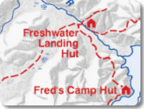
The forest changed back to scrubby brush, which would continue until
reaching the Freshwater River. There were DOC workers at the
Freshwater Hut doing renovations and it wouldn’t be possible
to stay
the night and DOC had just closed the next section of trail.
I
asked why and how bad the track was. They said it was flooded
and
didn’t recommend going on, which was both a professional and
personal
opinion. I couldn’t see it being as anything worse
than I’ve done
in Fiordlands and I struggled with what to do. I
didn’t come all
this way to skip part of the track but here were four very experienced
people advising against going on. I didn’t want to end up in the
newspaper with
the headline:
I debated what to do. I met Sarah, Mike, and Rob at the
hut. Sarah, who isn’t that tall, asked me,
“Did you see..”
I interrupted her mid-sentence, “Ah-Ah-Ah! Yes, up
to here
(motioning to my hip) with one leg.” She said,
“Ugh! Both
legs. Up to here (pointing to her
chest).” I imagine we
weren’t the first to be snagged by that puddle. The
workers
radioed for a water taxi back to Oban. It was the only option
and
reluctantly I took it.
The taxi negotiated the deeply flooded river, but I still had doubts
about not doing it. I was sure that I could have made it, but
caution was the word for the day. On my next trip to Stewart
Island I tramped the bypassed section and now know that track would
have been quite dangerous with the amount of rain that had
fallen. On the way back to Oban, I asked the driver if he
could
drop me off at the North Arm Hut. At least that would give me
the
self-respect of walking the last day. We arrived near the hut
and
I said goodbye to the four of them.
The hut was quiet with only one other couple there. A short
time
later, another couple arrived. They looked at me strangely (a
lot
of people look at me strangely, but it’s usually because
I’m wearing my
tights with penguins on them or running around in a loin cloth yelling
something about the End of the World), and said, “We met you
on the
Caples Track.” It was the couple that stayed at the
hut in the
meadows. I spent some time with them that night and stayed up
late reading and writing by candlelight. It was here, some
years
ago that I met, Rob and Valerie, with whom I had some of my best travel
times ever. It brought back a lot of memories. It started to
rain
and winds blew so hard I expected to hear the cracking sound of falling
trees. The rains came in horizontally all night.
Oban
 It was still raining and blowing in the morning, but by the time that I
left, the rain was at least coming down vertically. The
forest
was surprisingly pleasant, lush and green, with gentle ups and downs in
the track. It wasn’t a hard day, but a good
day. The track
went along Paterson Inlet and through the bush. It kept
raining,
but that’s ok, it was nice to be walking. The last
time through
this section, it was raining the same way, I’ll be
o.k. The track
crossed a small stream and reached a road that would lead to
Oban. I met two guys, Al and Trevor, who saw me walking in
the
rain and took my picture.
It was still raining and blowing in the morning, but by the time that I
left, the rain was at least coming down vertically. The
forest
was surprisingly pleasant, lush and green, with gentle ups and downs in
the track. It wasn’t a hard day, but a good
day. The track
went along Paterson Inlet and through the bush. It kept
raining,
but that’s ok, it was nice to be walking. The last
time through
this section, it was raining the same way, I’ll be
o.k. The track
crossed a small stream and reached a road that would lead to
Oban. I met two guys, Al and Trevor, who saw me walking in
the
rain and took my picture.
 I’m really glad that I tramped the Northwest
Circuit. Lots to
see, rocky outcrops, lush forest, great beaches, and...kiwis!
What more do you need? I really had doubts about the first
few
days and am glad I stuck it out. The last time I was on the
island, I turned back from the track. Something
didn’t feel right
about it. The track wasn’t too tough nor was I
unfit (to the
contrary, I was extremely strong), but a little voice inside me said,
“Nope, this doesn’t feel
right.” An experienced tramped learns
when to heed that voice, even if it’s not completely
understood.
The only regret this time was having to take a water taxi but that was
a good, safe decision. Some people will be turned off by the
amount of mud on the track and yes, it is a lot of mud but this is a
wilderness experience in an area that gets 4-5 meters of rain annually.
If you want an easier trail there is always the Rakiura
Track. Mud isn't something that is going to stop me.
I’m really glad that I tramped the Northwest
Circuit. Lots to
see, rocky outcrops, lush forest, great beaches, and...kiwis!
What more do you need? I really had doubts about the first
few
days and am glad I stuck it out. The last time I was on the
island, I turned back from the track. Something
didn’t feel right
about it. The track wasn’t too tough nor was I
unfit (to the
contrary, I was extremely strong), but a little voice inside me said,
“Nope, this doesn’t feel
right.” An experienced tramped learns
when to heed that voice, even if it’s not completely
understood.
The only regret this time was having to take a water taxi but that was
a good, safe decision. Some people will be turned off by the
amount of mud on the track and yes, it is a lot of mud but this is a
wilderness experience in an area that gets 4-5 meters of rain annually.
If you want an easier trail there is always the Rakiura
Track. Mud isn't something that is going to stop me.
I spent the day in Oban and had a good time with the people in the
hostel. One couple cooked up fresh cod they had caught and
baked
homemade bread for every one. If one has to be off the track,
one
might as well have that.
The following afternoon, a group of us went bird watching on Ulva
Island and then it was off to the ferry back to the South
Island.
I started to feel woozy on the way back and a cheerful guy brought
several others and myself to the back of the boat.
“It’s much
more stable there and the air is fresher” he said.
The swells
were up to four meters tall and we had to look up to see their
tops. I asked the guy, “Do you work
here?” He said, “No,
but I’ve done this hundreds of times and thought I would help
out.” I’m sure many people, many woozy
people, thought of him
quite highly. I met Al and Trevor on the boat and they gave
me a
ride into Invercargill. And so went my time on Stewart
Island.
If you've enjoyed reading about
this track, there are
several
other
tracks that might be of interest to you. They're all good
stories, I think you'll like them.