Southern Circuit:
Tramping Stewart Island is
known for mud and the Southern Circuit has lots of it. Yet
there
is more than that. It's quite a diverse track that goes
through
the mountains, along the ocean, into mossy gardens, and yes, some
really muddy marshes. If you want to see all the environments
Stewart Island has to offer in a single day of tramping, the Southern
Circuit/Bog Snorkel is for you.
North Arm Hut:
 It
was early in the season so there was no problem getting a standby
flight to Stewart Island. Compared to the ferry, the flight
was
$3 more, 2.5 hours less, and no seasickness. I've ridden the
ferry three times and each time it was awful. After picking
up a
personal locator beacon (used in case of a rescue) and registering with
DOC, there was nothing more to do, so off to the track.
It
was early in the season so there was no problem getting a standby
flight to Stewart Island. Compared to the ferry, the flight
was
$3 more, 2.5 hours less, and no seasickness. I've ridden the
ferry three times and each time it was awful. After picking
up a
personal locator beacon (used in case of a rescue) and registering with
DOC, there was nothing more to do, so off to the track.
At first, the Southern Circuit followed the Rakiura Track, which is
maintained for the typical tourist rather than the hard-core tramper
and wasn't difficult with moderate mud and extensive sections of
boardwalk. It went past the ocean and through pretty forests
that
abounded in ferns, both the small ones and others big as trees, and
lots of green. It was an easy and pleasant day of
walking.
It did hail a little but that didn't take away from anything.
Three hours later I arrived at the North Arm Hut. Today was
easy;
but I knew the next day wouldn't be that way.
Fred's Camp Hut:
The trail out of the North Arm Hut was very civil, boardwalked and all,
but then the two tracks split and the character of the trail
immediately changed. There were tree roots, rocks, mud, no
boardwalk and much less maintenance. There were several
streams
with deep channels. Luckily it wasn't raining; they would be
impassable in heavy rains. It was rugged but not so
bad.
The track started its climb over Thompsons Ridge and then the track was
looking bad.
 The
winds started to blow quite hard, requiring me to put my jacket
on. Putting it on was a good idea anyway as it started to
hail
too. It was a steep climb that soon turned into a real mess,
very
muddy and rugged. As the track went higher, the trail turned
into
a stream, with logs jumbled every which way. I've had tracks
with
logs across them but here I had to climb over logs sticking out and up
toward the sky, while a stream poured down around my boots.
It
was sloppy, very uncomfortable and no fun whatsoever. I've
done
more rugged tracks but this part sucked. That's the only way
it
can be described.
The
winds started to blow quite hard, requiring me to put my jacket
on. Putting it on was a good idea anyway as it started to
hail
too. It was a steep climb that soon turned into a real mess,
very
muddy and rugged. As the track went higher, the trail turned
into
a stream, with logs jumbled every which way. I've had tracks
with
logs across them but here I had to climb over logs sticking out and up
toward the sky, while a stream poured down around my boots.
It
was sloppy, very uncomfortable and no fun whatsoever. I've
done
more rugged tracks but this part sucked. That's the only way
it
can be described.
The track crested the ridge and started the descent. It was
exactly like the way up: no fun. I have since met many people
who
have tramped all over New Zealand, both Kiwis and foreigners, and many
people agree that Thompsons Ridge is as unpleasant as it
gets.
Once getting past the mess on the descent the sun came out and it was
rather pleasant. The track was still muddy but nothing too
unusual; besides, it was good to see the forest in the sunlight
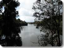
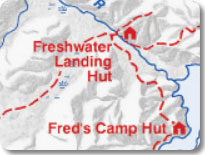
again. The track continued through the bush to Freshwater Hut
on
the banks of the Freshwater River.
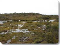
I had a little lunch and looked at the topographic maps. The
next
section looked easy with few hills but the map did say 'numerous swampy
patches'. I started off and found it to be quite accurate as
there were 'numerous swampy patches'. The track followed a
ridge
that was two meters higher than the overlying swamp. However
that
ridge ended and the trail descended into the marsh with sections of
open water that went beyond boggy. The track had one section
that
looked ominous. I eased into the puddle and found a muddy
shelf
just below the surface. I took a step, felt good.
Took
another step, felt good. Took another
ste.....sploosh! The
water was flowing, too slowly to see but just fast enough to form a
channel that one could tumble into. I went up to my chest in
soupy mud. It was hideous and smelled of rotten
eggs. I've
been in some pretty goopy situations when tramping but this was by far,
the worst. With the mud, my jacket was shiny black on the
outside...shiny black on the inside too.
There was a lot of open water in the marshes and I found that the
ground (if you could call it "ground") would give way and I would go
deep into the slop. There were often logs below the surface
and
sometimes I banged my knees on them plunging into the muck.
This
section was no fun. I try to appreciate every natural
environment
and there was a haunting starkness to the area but I didn't miss it
once the marshes were over and it was back into the trees.
The forest was nice and relatively dry. I heard birds singing
and
the surroundings were green. The track followed a sinuous,
deep
and placid stream that was so peaceful to look upon (though I suspect
in a rain this stream wasn't quite so idyllic). I noticed
that
there were no more track markers and I wondered if I was off-track. Was
this an animal track? I've gotten onto animal tracks in the
past
and sometimes it's hard to find the way back. I was about to
turn
around when an inviting orange trail marker appeared on a
tree.
The track started to have straighter, more open sections but there were
long stretches completely under flowing water. Not that I'm
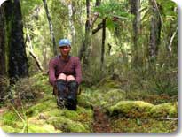
complaining; after that marsh this was a cakewalk.
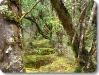
 Later
the track
started to resemble Fiordlands, with a deep green
forest, interspersed with deep puddles and thick, luxuriant vegetation
and mosses. It's quite beautiful and could be described as an
enchanted forest. It was absolutely magic. There
was something about this forest that moved me. It was so
green, so lush. It was so very peaceful, quiet, and
still. The
trail
started a series of up and downs during which it hailed quite
heavily. There were times the track was going up but the hail
was
very much coming down and the entire forest floor was covered in
pea-sized balls of ice. Some people might find hail
annoying. I found it wonderful. I'm always happy
and feel a
sense of wonder in these places. There is a naturalness to
it, a
feeling of being alive. It's good to experience the sun, it's
good to experience the winds, and it's the same for hail.
Later
the track
started to resemble Fiordlands, with a deep green
forest, interspersed with deep puddles and thick, luxuriant vegetation
and mosses. It's quite beautiful and could be described as an
enchanted forest. It was absolutely magic. There
was something about this forest that moved me. It was so
green, so lush. It was so very peaceful, quiet, and
still. The
trail
started a series of up and downs during which it hailed quite
heavily. There were times the track was going up but the hail
was
very much coming down and the entire forest floor was covered in
pea-sized balls of ice. Some people might find hail
annoying. I found it wonderful. I'm always happy
and feel a
sense of wonder in these places. There is a naturalness to
it, a
feeling of being alive. It's good to experience the sun, it's
good to experience the winds, and it's the same for hail.
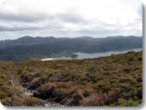
A few more climbs and from the top of one of them I could see
water on
three sides and it was likely the hut was nearby. A short
time
later, the track was along the inlet waters and a few more minutes led
to Fred's Camp Hut. I had it to myself, which was
nice. I
passed the evening sitting quietly and looking over the
waters.
Later I read by candlelight and that night I dreamed of the forest.
Rakeahua Hut:
 It
was a casual
morning as there was no hurry to leave. The
weather was pleasant (at least for now) and it was only a five-hour
walk to the hut. The track followed Paterson Inlet and then
pulled away from the water. It was pretty much as expected,
small
ups and downs with a few mid-sized climbs. It rained a little
and
then on one of the climbs started to hail. No biggie, put the
jacket hood up and keep tramping. The forest was nice and the
trail gentle. The birds were singing and the fantails were
fanning their tails. I even saw a kiwi from five meters away,
now
that's a treat.
It
was a casual
morning as there was no hurry to leave. The
weather was pleasant (at least for now) and it was only a five-hour
walk to the hut. The track followed Paterson Inlet and then
pulled away from the water. It was pretty much as expected,
small
ups and downs with a few mid-sized climbs. It rained a little
and
then on one of the climbs started to hail. No biggie, put the
jacket hood up and keep tramping. The forest was nice and the
trail gentle. The birds were singing and the fantails were
fanning their tails. I even saw a kiwi from five meters away,
now
that's a treat.
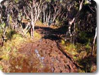 The
trail turned
wetter and based on the topographic map, it looked
likely to stay that way for a while. There were warnings in
the
hut logbook as to how wet the track could be and yes, it was a terrible
mess. There were long sections that were deep mud covered by
standing water above the knees and there was not a single a section
that could be called dry or even remotely approaching dry.
The
track followed the Rakeahua River. The river was within
centimeters (inches) of overflowing its banks but in some ways that
didn't matter as the entire floodplain was already
waterlogged.
Was it unpleasant? Well, one needs to accept the forest as it
is
and...nah, it was unpleasant. It was about 4 km. (2.5 miles)
of
really wet trail but the sun came out and that was a saving
grace. Eventually the track climbed ever so
slightly, just
enough to get above the slop and there were some dry, grassy sections
and then came the Rakeahua Hut.
The
trail turned
wetter and based on the topographic map, it looked
likely to stay that way for a while. There were warnings in
the
hut logbook as to how wet the track could be and yes, it was a terrible
mess. There were long sections that were deep mud covered by
standing water above the knees and there was not a single a section
that could be called dry or even remotely approaching dry.
The
track followed the Rakeahua River. The river was within
centimeters (inches) of overflowing its banks but in some ways that
didn't matter as the entire floodplain was already
waterlogged.
Was it unpleasant? Well, one needs to accept the forest as it
is
and...nah, it was unpleasant. It was about 4 km. (2.5 miles)
of
really wet trail but the sun came out and that was a saving
grace. Eventually the track climbed ever so
slightly, just
enough to get above the slop and there were some dry, grassy sections
and then came the Rakeahua Hut.
The muck of earlier today became part of the past as it turned into a
pleasant evening with gentle breezes, birds singing and a pretty
setting sun. I had forgotten about the slop but had a
sneaking
suspicion I would see plenty of it the next day. I fell
asleep
that night listening to the calling of kiwis rolling across the
valley. That's nice to hear drifting off to the nighttime
world.
Doughboy Bay Hut

 It
was quite cool
in the morning and I didn't feel like getting out of
my sleeping bag, besides it was raining off and on. I had
been
thinking about going to the Tin Ranges to the south of the track, but
with the weather being what it was, this had to be given a
pass.
The first few km. out of the hut were not quite as sloppy as yesterday
but close enough. A few places were thigh-deep mud and boggy
fields. If I could make it through yesterday and still enjoy
it,
today I could do the same. Eventually the track gained enough
elevation so as not to be quite so wet. The track returned to
the
forest of thick mosses. It's the sort of area that I never
tire
of. The track crossed the Rakeahua River on a wire bridge and
continued up the verdant valley. I walked through some really
nice spots with small openings in the forest allowing me to sit in the
sun next to the river. The sun felt good and the water tasted
sweet. Eventually the track started to climb away from the
river
and up the side of the valley; it was the main climb of the
day.
I could catch glimpses through the trees of the valley ahead and what
greeted me were waves of successive ridges. It was going to
be a
good tramp.
It
was quite cool
in the morning and I didn't feel like getting out of
my sleeping bag, besides it was raining off and on. I had
been
thinking about going to the Tin Ranges to the south of the track, but
with the weather being what it was, this had to be given a
pass.
The first few km. out of the hut were not quite as sloppy as yesterday
but close enough. A few places were thigh-deep mud and boggy
fields. If I could make it through yesterday and still enjoy
it,
today I could do the same. Eventually the track gained enough
elevation so as not to be quite so wet. The track returned to
the
forest of thick mosses. It's the sort of area that I never
tire
of. The track crossed the Rakeahua River on a wire bridge and
continued up the verdant valley. I walked through some really
nice spots with small openings in the forest allowing me to sit in the
sun next to the river. The sun felt good and the water tasted
sweet. Eventually the track started to climb away from the
river
and up the side of the valley; it was the main climb of the
day.
I could catch glimpses through the trees of the valley ahead and what
greeted me were waves of successive ridges. It was going to
be a
good tramp.
I continued on up and up through the forest and could see the
top of
the climb. It wasn't such a long distance. Turns
out that
it wasn't the top, and the next ridge was the top, and then the next
ridge would be the top and so on. The forest thinned and
turned
into alpine tussock. The higher the track went, the wetter it
became. The winds started to blow and then it rained, then it
snowed, and then it hailed. Eventually it stopped, well,
except
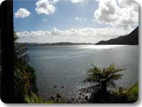
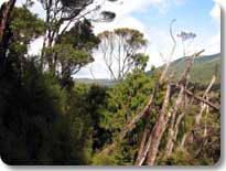
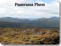
for the wind it stopped. The tops were glorious.
One could
see the Tin Ranges and the mountains to the south reared up behind the
ridges and beyond it all was the endless ocean. It was
somewhat
unexpected, but the tops were as boggy as down lower. The
track
meandered across the tops and it wasn't clear where the track was in
the distance so one just kept following the snow poles. I was
soaked, the temperatures dropped and the wind blew harder.
For
the first time, I started to get a little cold. No worries, I
was
well equipped, experienced, strong, and felt good about the day.
The track continued following the ridges up and then
down.
The
mountains were covered in short brush and I eventually reached the
descent where the forest once again turned thick. It was a
steep
descent and as long as you're cautious in your navigation and
footsteps, you'll be ok. The descent moderated and carried on
through the hills. Off in the distance I spied the first view
of
Mason Beach, a fifteen-km (nine-mile) long expanse of sand, which would
be tomorrow's destination. Then the track started its steep,
tricky downhill to Doughboy Bay. More vertical than
horizontal,
lots of tree roots and rocks, with a stream flowing down the
track. It was a good idea to hang onto the trees for safety,
one
false move and it's a broken ankle. The descent ended and it
was
a short walk to Doughboy Bay and then a little further down the beach
to the hut.
Today the views went to the edge of forever, the weather was somewhat
adverse, it was more than somewhat muddy and wet, but it was a fine day
of tramping. I looked forward to more of those conditions and
would certainly get them.
Mason Bay Hut
I walked down the beach toward a thundering waterfall and thought,
"Glad the track doesn't cross that stream." Three hundred
meters
later, the track did cross, D'oh! The stream was flowing fast
and
more than knee-deep, in other words, uncrossable. However,
there
were two flat-sided rocks that nearly spanned the stream which were
just under the water's surface. Hmmm...I went upstream of
these
rocks and tested the waters without my pack. If I braced
myself
against the rocks I could make it but had those rocks not been there, I
would have returned to the hut and waited until the stream
lowered. In general, the biggest hazard is flowing water and
you
need to take it seriously.
 The track
then climbed
steeply (and muddily) to the open tops similar
to yesterday. Lots of sharp deadwood in the mud puddles and
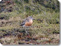
again, views near and far; it was nice. I saw a couple of
birds
and stopped to watch them. I thought them to be common but
when I
asked DOC about them, it turns out there are less than one hundred of
them left in the world due to invasive species. It saddens me
to
think that its come to that. I really wish people would get a
clue and realize that this is for real and once gone, these animals
aren't coming back. I'll cherish my memories of the Southern
New
Zealand Dotterel and hope they never disappear into that long night.
The track
then climbed
steeply (and muddily) to the open tops similar
to yesterday. Lots of sharp deadwood in the mud puddles and
again, views near and far; it was nice. I saw a couple of
birds
and stopped to watch them. I thought them to be common but
when I
asked DOC about them, it turns out there are less than one hundred of
them left in the world due to invasive species. It saddens me
to
think that its come to that. I really wish people would get a
clue and realize that this is for real and once gone, these animals
aren't coming back. I'll cherish my memories of the Southern
New
Zealand Dotterel and hope they never disappear into that long night.
The track started to descend and would be correspondingly steep to the
tramp earlier in the day. It was so overgrown sometimes I
wasn't
certain I was on the track anymore. As the path went lower,
it
moderated and turned into a comfortable, relatively dry forest
walk. It did rain and hail some parts of the day, but not the
majority, not so bad considering what's been seen so far.
I caught a glimpse of the ocean and before long one could see the
backsides of sand dunes. Fifteen minutes later I was on Mason
Beach. It was a seven km. (four mile) walk along the beach
but
the conditions deteriorated and the winds blew very hard.
Luckily
they were coming from behind as I was getting sandblasted. I
walked very fast as the weather was becoming quite unpleasant and the
tide was rising. I wasn't sure how far up the water would
reach
at high tide in these conditions. There was some concern as I
didn't see the hut turnoff as I approached within two km. of an island
that I passed when tramping the northern part of the Mason Beach two
years ago. Having to walk back into that wind was not an
appealing prospect. Shortly afterward, the turnoff to the hut
was
spotted and it was a twenty-minute walk inland to shelter.
There was only one other person there, Andrea from Italy. He
was
a nice guy and worked in Oban as a cook and we had a good time
together. Earlier, I thought I had missed the hut
but when
I looked at a map, the island that looked a couple km. away was
actually seven km. away. No worries. It rained in
the
evening and would continue to rain all night. This didn't
bode
well for tomorrow.
North Arm Hut
It was raining in the morning as we took off for the North Arm
Hut. The trail up to the to the Freshwater River is pretty
flat
and well maintained. There were some muddy sections but not
that
deep. It was an uneventful, but pleasant walk across the
Ruggedy
Flats with Andrea. The rain wasn't that hard nor was it too
cold
and it was still raining when we arrived at the Freshwater
Hut.
It had been raining non-stop for thirty hours and I knew the streams on
Thompsons Ridge would be impassable. Every time the rain
would
stop I'd say, "It will clear, it will clear" but five minutes later, it
was back to raining.
Andrea was waiting for a water taxi in the evening and I was beginning
to suspect I would have to take it. When the boat arrived,
the
captain said it was going to continue to rain and Thompsons ridge would
be a no-go. I didn't like the idea of taking a boat but
crossing
Thompsons Ridge was not an option. I had the taxi drop me off
at
North Arm Hut and said goodbye to Andrea and Ian, the captain, who
recognized me from two years before. The hut was pretty
quiet,
which was good. Late that night a kiwi called right outside
the
hut. It was out of bed and there it was. We could
see it in
the indirect light of our headlamps, well, that is until someone took a
flash picture and it ran away. Some people are lacking in
brains,
but that's the way it is.
Oban
 It
was a standard
Stewart Island day, raining off and on, and that's
certainly no barrier to tramping, is it? The walk was slow,
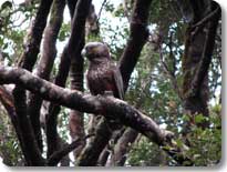
relaxing and pleasant, why hurry? There were kaka (a type of
parrot), fantails, wood pigeons, bush robins and bellbirds
calling. The forest was lush, green and vibrant.
When I
walked into Oban, it was raining. I've done three tramps on
the
island and each time it was raining when I walked into the
village. Thinking back, out of the seven days, it had hailed
five
of them. It's ok, it's Stewart Island. I checked on
flights, "One leaves in ten minutes" they said. I probably
should
have relaxed for a day or two, but impulsively took the flight and it
was back to Invercargill.
It
was a standard
Stewart Island day, raining off and on, and that's
certainly no barrier to tramping, is it? The walk was slow,
relaxing and pleasant, why hurry? There were kaka (a type of
parrot), fantails, wood pigeons, bush robins and bellbirds
calling. The forest was lush, green and vibrant.
When I
walked into Oban, it was raining. I've done three tramps on
the
island and each time it was raining when I walked into the
village. Thinking back, out of the seven days, it had hailed
five
of them. It's ok, it's Stewart Island. I checked on
flights, "One leaves in ten minutes" they said. I probably
should
have relaxed for a day or two, but impulsively took the flight and it
was back to Invercargill.
A few people have asked about the Southern Circuit and I ask why they
want to tramp it. I tell them it's a weeklong bog
snorkel.
The track is nice but I would recommend they tramp the Northwest
Circuit instead. It's nicer, more varied and not quite as
wet. If you don't have the time for the longer Northwest
Circuit,
then the Southern Circuit might be the better choice. One
thing
you can do is to combine the two tracks and skip the hike across
Ruggedy Flats, but this is a very long tramp.
Now that said, there were lots of really nice sections and great
views. I got to see two unusual birds, Kiwis and Dotterels
and
that is quite rare. Am I glad that I tramped the Southern
Circuit? You betcha!